


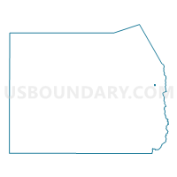
Tooele 17 Voting District, Tooele County, Utah
About
Outline

Summary
| Unique Area Identifier | 680039 |
| Name | Tooele 17 Voting District |
| County | Tooele County |
| State | Utah |
| Area (square miles) | 0.43 |
| Land Area (square miles) | 0.43 |
| Water Area (square miles) | 0.00 |
| % of Land Area | 100.00 |
| % of Water Area | 0.00 |
| Latitude of the Internal Point | 40.52852540 |
| Longtitude of the Internal Point | -112.30903100 |
Maps


Graphs
Select a template below for downloading or customizing gragh for Tooele 17 Voting District, Tooele County, Utah


Neighbors
Neighoring Voting District (by Name) Neighboring Voting District on the Map
- Tooele 01 Voting District, Tooele County, UT
- Tooele 06 Voting District, Tooele County, UT
- Tooele 15 Voting District, Tooele County, UT
- Tooele 16 Voting District, Tooele County, UT
- Tooele 18 Voting District, Tooele County, UT